The fuel situation across the country is still tense: some regions have introduced limits on liters per person, some gas stations are closing without warning, and pumps with the fuel grade you need run dry by noon. Now let me show you a really convenient tool — a fuel map right inside 2GIS. It covers almost all of Russia and, which is great for iPhone owners, works both in the app and through a regular browser.
Checking the gas station situation is easier with 2GIS
How the Fuel Availability Map in 2GIS Works
2GIS has launched a dedicated service that shows fuel availability at gas stations in real time. According to the developers, the map covers more than 29,000 gas stations — that’s practically every gas station in the country. You can open it right from the app’s home screen or at benzin.2gis.ru in a browser — no need to download anything extra.
The most interesting part is where the data comes from. There are two sources of information. The first is anonymized transaction data from Sber, which became a partner of the map: if someone recently paid for fuel at a gas station, there’s a high probability that fuel is still available there. The second source is drivers themselves, who mark the availability of different fuel grades right in the app. The result is a mix of banking statistics and live crowdsourcing, and this is exactly what makes the picture more accurate than maps that rely on a single data source.
According to the service’s own statistics, demand for tools like this has skyrocketed: gas station searches increased sevenfold compared to average figures from last year, with the peak on July 3 — when fuel was searched for 13 times more often than usual. So the tool arrived at just the right time.
How to Find a Gas Station with Fuel in 2GIS on iPhone
The search process itself is simple and doesn’t require any complicated workarounds. The whole logic is built around filters: you set the parameters you need, and the map highlights only the matching gas stations. Here’s how it works step by step:
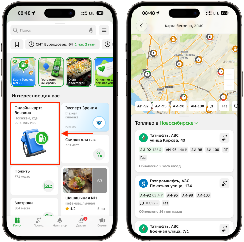
The gas station map opens right from the 2GIS home screen
- open the fuel map from the 2GIS home screen or via benzin.2gis.ru
- use the filter to select gas stations with the fuel type you need and an acceptable queue length
- open a station’s card to check fuel grade availability, restrictions, and how busy it is
- build a route directly from the card — the navigator will guide you to the pump, taking traffic into account
The main advantage over community-driven maps is that the route is built within the same app. No need to copy the address, jump to another navigator, and waste time — everything happens in one window. For iPhone users, this is especially convenient: 2GIS has long been stable on iOS, and the fuel map is already built into the current version, so you just need to update the app to the latest version.
If 2GIS isn’t showing what you need for some reason, it’s always useful to cross-check with an alternative. Checking multiple services at once is actually a golden rule during these stressful weeks, because data updates at different speeds across platforms.
Prices, Queues, and Restrictions at Gas Stations in 2GIS
The map is great not just for marking working gas stations. Each station’s card contains a lot of useful information, and it’s worth opening it before heading out rather than driving blind. Here’s what you can find there:
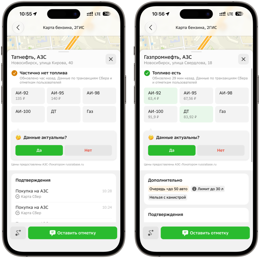
All the information you need will be available
- which fuel types are available — from Regular 92 to diesel
- current prices for each grade
- dispensing restrictions: liter limits or bans on filling jerry cans
- whether there’s a queue and how long it is
It’s the combination of price, queue, and limit information that saves your nerves. It’s one thing to drive to a gas station and calmly fill up with Premium 95, and quite another to find out on the spot that they won’t give you more than 20 liters. The map warns you about this in advance, so you can decide whether to go there or look for a less crowded option a bit farther away.
Different services take different approaches, but the essence is the same — fewer surprises at the pump.
How Accurate Is the Fuel Data in 2GIS
I’ll be honest: no fuel map gives a 100% guarantee. The situation at gas stations changes literally within half an hour — fuel was there in the morning, and by noon it’s all gone. Sber’s data shows purchase facts but with a slight delay, and driver reports depend on how actively people in your city use the service. So it’s worth double-checking how fresh the information is before every trip.
Nevertheless, 2GIS has a serious advantage in coverage: 29,000 gas stations is really almost the entire country, not just a couple of major cities. Plus, the data is backed by bank transactions rather than relying solely on the goodwill of users. Compared to community-driven maps, this looks more robust.
Who needs this the most? Everyone who regularly drives and has at least once ended up at an empty pump or in a half-hour queue. For iPhone owners, the tool is free and hassle-free: many people already have 2GIS installed, and the web version can simply be opened in Safari and even saved as an icon on the home screen. My conclusion is simple — in times like these, having such a map on your phone definitely won’t hurt, especially if you’re planning a long trip and don’t want to pray at every gas station along the way.